

Tourist Information
- » Location - How to get there
- » History of the Council
- » Illustrious People
- » Parishes
- » Our Villages
- » Places to eat and drink
- » Accommodation
- » Places of Interest
- » Walking Routes
- » Viewpoints and Picnic Areas
- » Nature
- » Beaches
- » Gastronomy
- » Photo Gallery
- » Postcards
- » Tourist Information Centre
- » Caravan`s service area
- » Arnelles Beach - Webcam
Walking Routes
COASTAL WALK BETWEEN ORTIGUERA AND VIAVÉLEZ E-9
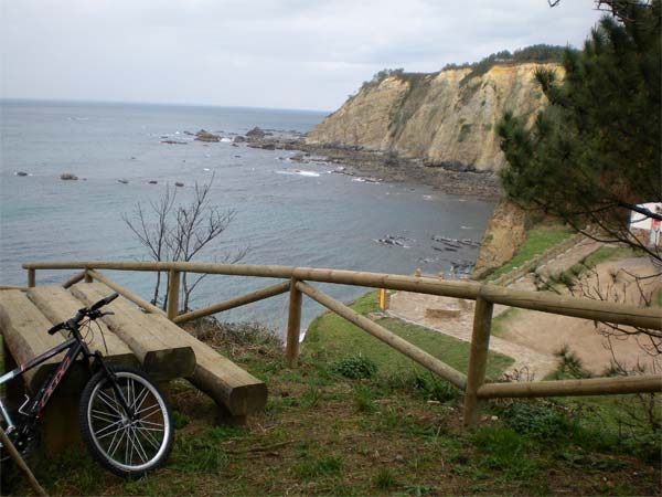 This stretch of the route starts at the fishing village of Ortiguera and ends in Viavélez, a small village that belongs to our neighbouring council of El Franco. The distance is 14.5 km. and the maximum height is 70 m. It will take 5 hours return, approx. This path is suitable both for walkers and cyclists (MBT). It is considered to be an easy walk.
Access:
Once in the village of Jarrio, on the main road N-634, we need to take the turnoff to the regional hospital. Then, we follow the local road CÑ-4 to Ortiguera and we follow the road signs towards the harbour. On our way to the harbour, we take the last turning on the left and as we go up a little slope among the houses we turn again to the right. The coastal walk starts a few meters ahead.
Along this route, we will go through the villages of Medal, Loza and Cartavio. Between these villages we will discover a coastline dotted with a lot of cliffs, beautiful and quiet beaches like Torbas, Figueira, Armazá..... rest areas and breathtaking views over the Cantabrian Sea.
HILL RANGE ROUTE OF COAÑA
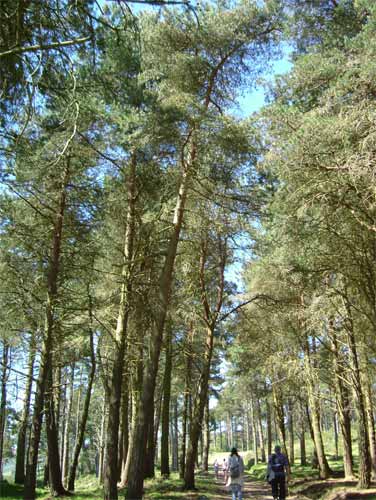 This route starts in Bustabernego (Trelles) viewpoint and ends in the well-known Castro of Coaña (Hill-fort of Coaña). The walk is approx. 14,782 km long so it is considered to be a short hill-walking route. The estimate time is 3 hours and 40 minutes and it can be done on foot or by bike.
Unload here the map of this route.
Access:
On the main road N-634, at the village of El Espin, we take the road AS-12 to Trelles (kilometre 9) and a few meters ahead we turn right towards Teixedo, following, from this point onwards, the signposts to the viewpoint.
From Bustabernego viewpoint, the panorama is wide and varied. To the north we can enjoy the views over the Cantabrian Sea, Navia’s valley and several fishing villages. To the east we will see some riverside villages and overall views of the bordering councils. Soon after starting the route, we reach the hill Seya Fermosa, the highest point at 710 m., and from here we start to descend slowly, leaving behind the views over the villages of Las Mestas, Nadou, Llosoiro and El Villar de Coaña. Soon, the path reaches an asphalt road and arrives in Coaña, where we will take the turning to the village of
Busnovo on our right and the Castro (hill-fort) of Coaña, where the route ends.
ETHNOGRAPHIC ROUTE
The Ethnographic Route is a guided route taken in summer and along its itinerary we can discover different cultural elements.
This route is done with a guide every Wednesday in July and August. The itinerary is enjoyable, and the starting point is the Town Hall square.
The route starts at 11.00 am. and ends at 14.00 p.m. The variety of the culture and landscape is its most appreciated quality.
The Discoidal Stele, the old typewriters and musical devices private collections that Mr. José Manuel Acevedo has in the village of Coaña and the Castro (hill-fort) of Coaña are the most outstanding resources, although the traditional and industrial architecture doesn’t go unnoticed to the walkers.
Discover through this route, the history of Coaña and its inhabitants.
No previous registration is necessary and the prices are:
Adults: 3 €
Children under 5 years: Free of charge
Children from 5 to 15: 2,5 €
Senior: 2,5 €
Groups (15 or more): 2 €
Plaza del Ayuntamiento, s/n
33795 Coaña (Asturias)
Phones: (+34) 985 47 35 35 - (+34) 985 63 08 01
Fax: (+34) 985 63 04 68
Legal warning